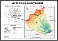
Land use/cover change and transormations in Upper Runde Sub-catchment area in Zimbabwe
Abstract
The study assessed land use/cover changes in the Upper Runnde sub-catchment in Zimbabwe between 2000 and 2020 using GIS and remote sensing techniques with the support of interviews and field observations. Faster land use/cover changes were experienced within the 2000–2010 decade when compared to the 2010–2020 decade; for instance, bare land increased by 92.1% between 2000–2010 compared to 16.5% between 2010–2020. Major land cover transformations included change from forest land to bare land, grassland and shrub land, and change from grassland to bare and shrub land to grassland. The results confirmed conversion of forests to agricultural lands and settlements following the fast-track land reform program in 2000, and livestock increase induced overgrazing as major human activities driving land cover changes. There is a need for serious attention from resource management stakeholders before depletion of critical resources like water and woodlands. Therefore, the Ministry of Lands, Agriculture, Water, and Rural Resettlement and the Zimbabwe National Water Authority may consider strict auditing of land uses and water resource use in catchment areas to guard against encroachment of agriculture and other land uses in protected lands and fragile ecosystems like water bodies and wetlands.
References
[1]Turner BL, Moss RH, Skole DL. Relating Land Use and Global Land Cover Change: A Proposal for an IGBP-HDP Core. IGBP-HDP Working Group on Land use/land Cover Change; 1993.
[2]Foley JA, Ramankutty N, Brauman KA, et al. Solutions for a cultivated planet. Nature. 2011; 478(7369): 337-342. doi: 10.1038/nature10452
[3]FAO. Global Forest Resources Assessment: How are the World’s Forests Changing?, 2nd ed. Food and Agriculture Organization of the United Nations; 2016.
[4]Barati AA, Zhoolideh M, Azadi H, et al. Interactions of land-use cover and climate change at global level: How to mitigate the environmental risks and warming effects. Ecological Indicators. 2023; 146: 109829. doi: 10.1016/j.ecolind.2022.109829
[5]Paiboonvorachat C. Using Remote Sensing and GIS Techniques to Assess Land Use/Land Cover Changes in the Nan Watershed, Thailand. Southern Illinois University at Carbondale; 2008.
[6]Lambin EF, Meyfroidt P. Global land use change, economic globalization, and the looming land scarcity. Proceedings of the National Academy of Sciences. 2011; 108(9): 3465-3472. doi: 10.1073/pnas.1100480108
[7]Gebreslassie H. Land use-land cover dynamics of Huluka watershed, Central Rift Valley, Ethiopia. International Soil and Water Conservation Research. 2014; 2(4): 25-33. doi: 10.1016/S2095-6339(15)30055-1
[8]Lin X, Xu M, Cao C, et al. Land-Use/Land-Cover Changes and Their Influence on the Ecosystem in Chengdu City, China during the Period of 1992–2018. Sustainability. 2018; 10(10): 3580. doi: 10.3390/su10103580
[9]Jones A, Smith B, Williams C. Land use changes in the Mississippi River catchment area: a multi-method analysis. Environmental Science Journal. 2022; 10(3): 345-360.
[10]Smith E, Johnson L, Brown P. Urbanization and forest cover changes in the Rhine River catchment area: a remote sensing approach. Landscape Ecology Journal. 2023; 18(2): 210-225.
[11]Achard F, Beuchle R, Mayaux P, et al. Determination of tropical deforestation rates and related carbon losses from 1990 to 2010. Global Change Biology. 2014; 20(8): 2540-2554. doi: 10.1111/gcb.12605
[12]Nzabarinda V, Bao A, Xu W, et al. Impact of cropland development intensity and expansion on natural vegetation in different African countries. Ecological Informatics. 2021; 64: 101359. doi: 10.1016/j.ecoinf.2021.101359
[13]Mayaux P, Bartholomé E, Fritz S, et al. A new land-cover map of Africa for the year 2000. Journal of Biogeography. 2004; 31(6): 861-877. doi: 10.1111/j.1365-2699.2004.01073.x
[14]CILSS. Landscapes of West Africa. A window on a changing world: Ouagadougou: Burkina Faso. Available online: https://doi.org/10.5066/F7N014QZ (accessed on 11 September 2020).
[15]Cotillon SE, Mathis ML. Mapping Land Cover through Time with the Rapid Land Cover Mapper—Documentation and User Manual. U.S. Geological Survey; 2017. doi: 10.3133/ofr20171012.
[16]Kiros MH. Temporal and Spatial Changes in Land Use Patterns and Biodiversity in Relation to Farm Productivity at Multiple Scales in Tigray, Ethiopia [PhD thesis]. Wageningen University; 2008.
[17]Hussein AO. Land Use and Land Cover Change, Drivers and its Impact: A Comparative Study from Kuhar Michael and Lenche Dima of Blue Nile and Awash basins of Ethiopia [Master’s thesis]. Faculty of the Graduate School, Cornell University; 2009.
[18]Hailu A, Mammo S, Kidane M. Dynamics of land use, land cover change trend and its drivers in Jimma Geneti District, Western Ethiopia. Land Use Policy. 2020; 99: 105011.
[19]Chenje M, Sola L, Paleczny D. The State of Zimbabwe’s Environment. Government of Zimbabwe, Ministry of Mines, Environment and Tourism; 1998.
[20]Matsa M, Muringaniza K. Rate of land use/land cover changes in Shurugwi District, Zimbabwe: Drivers for change. Journal of Sustainable Development in Africa. 2010; 12(3): 107-121.
[21]Matsa M, Mupepi O, Musasa T, et al. A GIS and remote sensing aided assessment of land use/cover changes in resettlement areas; a case of ward 32 of Mazowe district, Zimbabwe. Journal of Environmental Management. 2020; 276: 111312. doi: 10.1016/j.jenvman.2020.111312
[22]Ziti C, Chapungu L, Nhamo G. Climate Change Response Strategies and Implications on Sustainable Development Goals in Mutirikwi River Sub-Catchment of Zimbabwe. Journal of Environmental Geography. 2024; 17(1-4): 1-14. doi: 10.14232/jengeo-2024-44881
[23]Bird’s life Zimbabwe. Keeping common birds common. Available online: http://www.birdlifezimbabwe.org/e_publications.com (accessed on 13 April 2021).
[24]Zimbabwe National Statistics Agency web. Available online: http://www.zimstats.2012 (accessed on 16 March 2021).
[25]Fetters MD, Curry LA, Creswell JW. Achieving integration in mixed methods designs—principles and practices. Health Services Research. 2013; 48(6pt2): 2134-2156.
[26]Koranteng A, Adu-Poku I, Frimpong BF, et al. Urbanization and Other Land Use Land Cover Change Assessment in the Greater Kumasi Area of Ghana. Journal of Geoscience and Environment Protection. 2023; 11(05): 363-383. doi: 10.4236/gep.2023.115022.
[27]Jagtap AA, Shedge DK, Degaonkar V, et al. Time Series Analysis of Urban Expansion Using Land-Use and Land-Cover Change Detection of LANDSAT Imagery for Pune District of Maharashtra. In: Proceeding of 2023 12th International Conference on Advanced Computing (ICoAC); 17-19 August 2023; Chennai, India. pp. 1-6. doi: 10.1109/icoac59537.2023.10249630
[28]Toma MB, Belete MD, Ulsido MD. Historical and future dynamics of land use land cover and its drivers in Ajora-Woybo watershed, Omo-Gibe basin, Ethiopia. Natural Resource Modeling. 2022; 36(1). doi: 10.1111/nrm.12353
[29]Gumindoga W, Rwasoka DT, Ncube N, et al. Effect of landcover/land-use changes on water availability in and around Ruti Dam in Nyazvidzi catchment, Zimbabwe. Water SA. 2018; 44(1): 136-145.
[30]Ivanov VY, Kotarba A, Barrett M. Impacts of land use changes on water resources in the Carpathian Mountains. Hydrological Processes. 2012; 26(10): 1521-1535.
[31]Pacheco P, Santos M, Silva R. Effects of land use changes on water resources in the Amazon Basin. Water Resources Research. 2016; 42(3): 321-335.
[32]Wang Y, Sun G, Hou J. Impacts of land use changes on watershed hydrology in the Yangtze River Basin. Hydrological Sciences Journal. 2014; 59(3): 52-68.
[33]Wang H, Chen J, Liu L. Land use dynamics in the Yangtze River catchment area: implications for water quality and quantity. Regional Environmental Change. 2021; 5(4): 312-325.
Copyright (c) 2023 Oshneck Mupepi, Rumbidzai Chinyemba

This work is licensed under a Creative Commons Attribution 4.0 International License.
Authors contributing to this journal agree to publish their articles under the Creative Commons Attribution 4.0 International License, allowing third parties to share their work (copy, distribute, transmit) and to adapt it for any purpose, even commercially, under the condition that the authors are given credit. With this license, authors hold the copyright.


